
|
|||
| Contents | Prev | Next | |
![]()
11. Earth has Expanded and Continents are Drifting!
The fact is that there are parts of the continental crust, have been shaped in such a way, so that if they are pushed side by side they would fit together.
On the other hand, there are theories. But theories are not facts. They can be right or wrong. Any theory is just a thought trying to explain a fact, when the real cause of the fact is unknown.
The dominant theory for explaining the earth shaping is the Plate Tectonics, also called the Continental Drift. Another less famous theory is the Expanding Earth. (wikipedia.org)
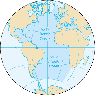
World map; Atlantic centered
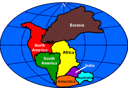
The tectonic theory states that the continents before 200 million years were in one single land sitting in a very vast ocean (right). And then these land chunks started to move, without any reason, and without any defined dynamic process! And because no reason is given for their movements, they are called, sometimes, wandering plates.
A major problem with the tectonic theory is that it views the world map from the Atlantic Ocean only, neglecting the Pacific, because the theory does not have an explanation for the matching edges on the pacific.
There are parts on the map, if they are viewed from the other side, from the pacific, they will fit perfectly too!
The expanding (continuously expanding) earth theory is more reasonable, because it deals with the map from all angles.
However, neither the Expanding Earth theory has an answer for why the earth is expanding, nor the Tectonic theory has an answer for why the so-called plates sat stationary for a very long time and then started to move all of a sudden. Moreover, both theories are not taking into consideration the ages of the lowlands of the other inner planets!
Regarding the Expanding Earth theory, the earth is not continuously expanding, it has just expanded once.
The fact is that neither the ocean floor existed nor the continents have ever moved before 200 million years.
If we take everything related to the earth structure into account, not ignoring anything, we have to say the Earth has expanded, and the continents are drifting. In other words, the Expanding Earth theory and the Continental Drift theory are both correct in certain aspects.
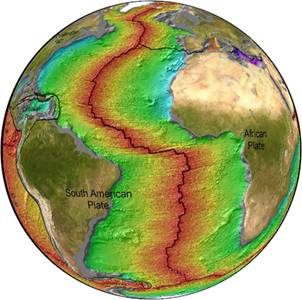
Atlantic-centered world map
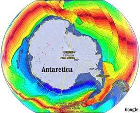
Antarctica; ridges from all sides, no trenches
By looking at the mid-ocean ridge of the Atlantic, it can be seen clearly that the continents on both sides of the Atlantic are being pushed away from each other. The red color represents the newest seafloor. The yellow areas are older than the red, and so on. The green seafloor is about 150 million years old. (sos.noaa.gov)
Antarctica is another example of the continental drift. It is surrounded by ridges from all sides. No trenches are found inside the circle of ridges of Antarctica.
The continents did not sit stationary for a long period of time, and all of a sudden started to move without any reason. The expansion of Earth, and the water that filled the ocean basins, as we will see in the next section, are the reasons behind the drift of the land chunks.
Next we will see that there are parts of the world do fit together from the Pacific Ocean.
Pacific-centered world map
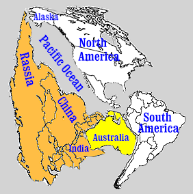
From the world map above, which is the Pacific Ocean centered, the shape in the picture to the right was produced.
A very simple turning of the colored areas, and without any artwork, we have something on the other side of the map that fits perfectly.
It is true that the parts that fit together from the other side are more, but not all of them do fit. The Mediterranean Sea doesn't fit, the Black Sea doesn't fit, the Gulf of Mexico doesn't fit, and many other areas do not fit.
The point is that we are NOT dealing with something that works according to a systematic natural law, but with an accident! Therefore, we should not expect, for example, a car accident to dismantle the car very nicely! Some parts may remain intact, but not all.
The Atlantic resulted from a crack in the basaltic layer at a late time, whereas the Pacific resulted from the initial explosion in the earth's crust, when the internal gas pressure exceeded the maximum limit. This fundamental difference in the way the two areas were separated produced different results.
At one period of time, the Pacific Ocean was small, just as it is shown in the picture above. Later on, the brown area was pushed away. And at a very late time, Australia separated.
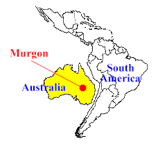
Fossil discoveries prove that Australia and South America were connected together at least 50 million years ago.
"The first evidence we have of marsupials [kangaroo-like
animals] in Australia comes from the 55 million-year-old fossil site at
Murgon in southern Queensland. This Murgon site has yielded a range of
marsupial fossils, many with strong South American connections. At Murgon
there is also evidence of a placental mammal, known as a condylarth. Placental
mammals were also found in North America and
South America at this time."
australia.gov.au
This fossil record is a shortcut for knowing that Australia was attached to South America at some period of the earth's history. From the other side of the pacific, the map shows China and India were connected to Australia. The pacific was initially small. All of this leads to a conclusion that Earth expanded.
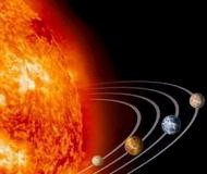
Not only the earth expanded, but also all of the inner planets, and also the planets of the second sun:
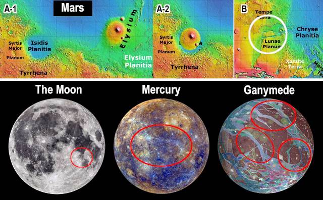
The upper part of the picture above is of Mars; figure A-1 shows a rounded lowland; A-2 shows that the piece of land where the volcano is fits in the rounded lowland. Figure B shows a white circle and a piece of land inside; this piece of land fits the land edges from two sides with a little distortion.
The bottom part of the picture shows the moon, Mercury and Ganymede (a planet of the second sun); the red circles show the matching edges.
Basically all rocky planets in the solar system have expanded, whether they are planets of the existing sun or the second sun, they all have matching edges, and if it is possible to carbon date the lowlands of these planets accurately, their ages will be found about 200 million years old only, as old as the ocean floor on earth. Unlike Earth, the other planets are inactive geologically; they expanded once, and then they remained stationary. The water is the main factor that makes the land chunks on Earth drift continuously.
![]()
| The full report in a single page | ||
| Contents | Prev | Next |